SEPA.ca
  • HOME
    • Mission/Vision Statements
    • Board of Directors
    • Directors Nomination and Election
    • SEPA Annual Scholarship
    • History
    • Membership
  • Planning Tools
    • Public Safety Sites
    • MECC 2018
    • The Canadian Disaster Database (CDD)
    • CanOps - MASAS
    • EPIC Podcasts
    • Business Continuity
    • Live World Emergency Map
    • Search and Rescue Saskatchewan Association of Volunteers
  • Connect With Us
  • Members Home
    • 2022 Presentations
    • 2019 Presentations
    • 2018 Presentations
    • MECC 2018
    • 2017 Presentations
    • 2016 Presentations
    • 2015 Presentations
    • 2022 AGM
    • 2019 AGM
    • 2018 AGM
    • 2017 AGM
    • SEPA Bylaws
  • 2023 Conference
    • 2023 Sponsors and Trade Show >
      • 2023 Sponsor Opportunities

​The Canadian Disaster Database (CDD) 

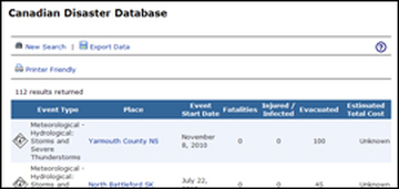
The Canadian Disaster Database (CDD) contains detailed disaster information on more than 1000 natural, technological and conflict events (excluding war) that have happened since 1900 at home or abroad and that have directly affected Canadians. The CDD tracks "significant disaster events" which conform to the Emergency Management Framework for Canada definition of a "disaster" and meet one or more of the following criteria:
  • 10 or more people killed
  • 100 or more people affected/injured/infected/evacuated or homeless
  • an appeal for national/international assistance
  • historical significance
  • significant damage/interruption of normal processes such that the community affected cannot recover on its own
The database describes where and when a disaster occurred, the number of injuries, evacuations, and fatalities, as well as a rough estimate of the costs.  As much as possible, the CDD contains primary data that is valid, current and supported by reliable and traceable sources, including federal institutions, provincial/territorial governments, non-governmental organizations and media sources.  Data is updated and reviewed on a semi-annual basis.

Geospatial
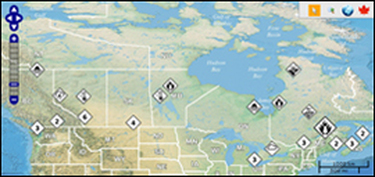
A geospatial mapping component has been added to the CDD, which enables users to define their search of the disaster database by using a spatially-defined area. It also displays query results charted across a map. Geospatial disaster data contained in the CDD can be exported through KML or GeoRSS feeds. Data from both the Classic CDD and the Geospatial CDD can be downloaded into report formats.

Enter the Geospatial Canadian Disaster Database
​
(requires JavaScript)
Enter the Classic Canadian Disaster Database 
(does not require JavaScript)
Picture
Picture
  • HOME
    • Mission/Vision Statements
    • Board of Directors
    • Directors Nomination and Election
    • SEPA Annual Scholarship
    • History
    • Membership
  • Planning Tools
    • Public Safety Sites
    • MECC 2018
    • The Canadian Disaster Database (CDD)
    • CanOps - MASAS
    • EPIC Podcasts
    • Business Continuity
    • Live World Emergency Map
    • Search and Rescue Saskatchewan Association of Volunteers
  • Connect With Us
  • Members Home
    • 2022 Presentations
    • 2019 Presentations
    • 2018 Presentations
    • MECC 2018
    • 2017 Presentations
    • 2016 Presentations
    • 2015 Presentations
    • 2022 AGM
    • 2019 AGM
    • 2018 AGM
    • 2017 AGM
    • SEPA Bylaws
  • 2023 Conference
    • 2023 Sponsors and Trade Show >
      • 2023 Sponsor Opportunities